Welcome to the scientific publication page!
Thank you for respecting the rights of the authors who have worked hard for these different articles. Enjoy reading and thank you!
Published in 2020
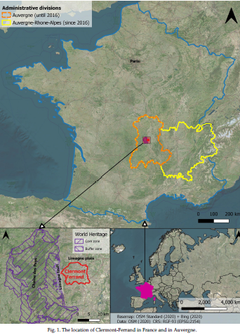
THE URBAN GEOHERITAGE OF CLERMONT-FERRAND: FROM INVENTORY TO MANAGEMENT
An article by : Viktor Vereb, Benjamin van Wyk de Vries, Marie-Noëlle Guilbaud, Dávid Karátson
Abstract
In sprawling urban areas, geoheritage is suppressed into limited niches. Potential geosites are highly vulnerable and could disappear completely during construction, or their integrity could be irreversibly modified. Here, we create an inventory of urban geoheritage for Clermont-Ferrand in France, recording more than 50 sites using the French national workflow. The results of the quantitative assessment have been used to differentiate between geosites (high scientific value) and geodiversity sites (limited scientific significance, important additional values). Finally, we discuss some important considerations on urban geoconservation, such as geotouristic itineraries or customized management
strategies for each site and the whole city.
Published in 2020
GEOHERITAGE AND RESILIENCE OF DALLOL AND THE NORTHERN DANAKIL DEPRESSION IN ETHIOPIA
An article by : Viktor Vereb, Benjamin van Wyk de Vries, Miruts Hagos, Dávid Karátson

Abstract
The Danakil Depression, located in the northern segment of the Afar rift, is a world-class example of active rifting and the birth of a new ocean. The unique, yet only partially interpreted geothermal system of Dallol in northern Danakil is currently receiving renewed attention by researchers and visitors despite its extreme climate since the recent improvements of infrastructure and the stabilisation of Ethio-Eritrean political relations. Previous studies focused on the general geological description, the economic exploitation of potash reserves and interpretation of the complex hydrothermal processes. Continuing monitoring of geothermal activity has not yet been carried out, and the valorisation of local geoheritage has not accompanied the increased interest of tourists. Here, we present a three-step study in order to demonstrate the unique geological environment and international geoheritage significance of Dallol and Danakil. A three-year-long remote sensing campaign has been done to provide information on improving the resilience of visitors through interpreted, monthly hazard maps, and on following up the changes of geothermal activity. Over the same time, the first geoheritage assessment of the region for 13 geosites was carried out along with a
comparative analysis of three quantitative methods (to evaluate the scientific importance and the geotouristic development potential of the area). Finally, with the input of the assessment, a preliminary geoheritage management plan was created for practical consideration by stakeholders toward a geoconservation and geotourism development, as well as a resilience system of this peculiar area.
Published in 2020
The Ghosts of Old Volcanoes, a Geoheritage Trail Concept for Eastern Coromandel Peninsula, New Zealand
An article by :Ilmars Gravis, Károly Németh, Chris Twemlow, Boglárka Németh

Abstract
Re-imagining the geotourism experience through the lens of slow tourism, in this paper we lay out a pathway towards a more nourishing, engaging, and educational experience that contributes to both geoconservation and a reshaping of the tourism economy in light of recent disruption caused by the Covid-19 pandemic. Evidence suggests that to date, and further highlighted by unfolding local and global responses to the pandemic, mainstream approaches to conservation, protection, and tourism have poorly served our unique geoheritage landscapes and features. We demonstrate the potential for community led development utilising internationally recognised practises to provide a foundation for low impact and sustainable tourism, education, and training opportunities of benefit to local, regional, and national communities. We identify the eastern Coromandel, including Kuaotunu Peninsula, as an area for potential research and identification of sites with high geological, environmental, and cultural values. A geotrail has the potential to tell the story of formation of rhyolitic caldera walls enclosing translucent azure waters framed by white silica sands. Cultural sites are a landscape record giving voice to indigenous Māori that began the human story of adapting to and modifying the landscape. Our premise is that a geotrail offers a more sophisticated experience by weaving together conservation stories, science communication, indigenous history, and local lore. Our goal is to develop a physical and virtual geotrail, complemented by learning and promotional media highlighting the layers of natural and human history, building on a foundation of already published scientific, social, and historical research. Global disruption caused by the current pandemic gives us cause to reflect and consider management of a growing tourism footprint and economic reliance on singular landscapes. We recognise this as an opportunity to reassess a tourism model based on a high-volume of short stay visits to iconic sites.